|
Northwestern Watershed of
|
|
Many small nameless tributaries come together in the Northwestern Watershed to form Accotink Creek. We have photos and descriptions for two of these branches. More need to be documented.
North Fork of Accotink Creek June 15, 18, & July 5, 2018: Walked upstream along the North Fork of Accotink Creek in the Northwest Watershed area.
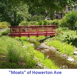
The North Fork flows entirely within Fairfax City. It joins main Accotink Creek in Ranger Road Park. Immediately upstream from the mouth, it is fed by the unnamed tributary that flows through Dale Lestina Park. The unnamed tributary from the Mosby Woods area feeds the North Fork in the Willow Woods Open Space. Just a few yards upstream from this junction, the North Fork suffers the indignity of being confined in a storm drain for about 1/2 mile upstream from Eaton Drive. A short open section above Eaton Drive appears on maps, but seems to have been recently sacrificed for redevelopment of a shopping center. Open water can again be found upstream just west of Chain Bridge Road. At its far upstream end, above Howerton Ave, the North Fork is confined in a concrete channel.
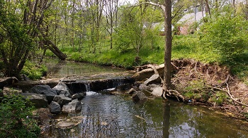
The North Fork enjoys wide forested buffers along its lower length in Ranger Road Park, Stafford Park, and Willow Woods Open Space. There are some places where the buffer is narrower on one side or the other, particularly on the Ranger Road side near the mouth, and where a few property owners have mowed too near the banks. Upstream from Plantation Drive, the trees appear to be younger. The buffer and the cooling shade provided by trees may contribute to the abundance of small fish in the North Fork. Swirling schools are visible nearly every step of the way, as far upstream as Howerton Drive. The 12-inch drop at the Plantation Drive culvert would seem to be impassible, but fish may manage to get by during high water. The extended portion contained in storm drains must also be too daunting for fish to pass except when swept downstream through the pipe by high water. The amount of trash is moderate along most of the North Fork. Invasive alien plant species are present all along the North Fork, including Porcelainberry, Oriental bittersweet, Japanese stilt grass, Bush honeysuckle, Multiflora rose, and more. Infestations tend to be lesser in the shadier areas. Invasives are more prevalent in the younger forest areas in the parks upstream from Planation Drive. Just as streams flow downhill, so do sewer pipes. A cleared strip along the path of the sewer line runs next to the North Fork along its lower length. The cleared strip is often the path of least resistance for walking, as there is no formal trail development along the creek and informal trails are largely missing as well. This appears to indicate this area of the North Fork is little-visited by its neighbors despite being in public parks. It's true that formal public access is limited to a few points, notably at the mouth in Ranger Road Park and at Stafford Road Park. Stream stabilization projects cover the entire lower length of the North Fork. U-shaped rock vanes one after another turn much of the stream into a series of stepping pools. These vanes may have been designed with fish passage in mind, as they are low and provide gaps that facilitate swimming through. There do not seem to be stream restorations upstream from Chain Bridge Road. Between Eaton Place and Chain Bridge Road, the North Fork is confined to a storm drain. Upstream from Chain Bridge Road, the North Fork flows almost entirely through private lots, with short segments in Cobbdale Park and the common property of The Assembly community. Buffer is a mix here, with many yards mowed to the bank, but the last few upstream lots are large and wooded. The houses along the south side of Howerton Ave have the North Fork as a "moat", flowing through their front yards and crossed by private bridges. One lost little branch feeding the North Fork can be found in the open only for a 200-yard segment in a concrete channel alongside Egan Drive. See all the June 2018 North Fork Photos at Shutterfly.com The North Fork was the focus of a contentious project in 2007 to install playing fields that replaced a formerly wooded area. MORE HERE and HERE . The same year, there was also a fish kill caused by careless swimming pool discharge. MORE HERE Draper Drive Tributary July 2, 2018: Walked upstream along the Draper Drive tributary of Accotink Creek This unnamed tributary is referred to by the name of a nearby street and park. The tributary joins Accotink Creek in Draper Drive Park, just north of Fairfax Blvd in Fairfax City. The tributary runs parallel to Draper Drive along its lower length, so buffer is limited along the eastern bank. On the western bank, buffer stretches off into the distance, in the parks flanking Accotink Creek. Shortly upstream, buffer narrows on the western bank as well, constricted by the playing fields and parking lot of Draper Drive Park. There are stoneworks from stream restoration projects all along this lower section of the Draper Drive tributary. Not all of them have fared well, having been bypassed in paces by the stream finding its own course and resuming the erosion of the banks that the projects were intended to prevent. Fish are common along the lower Draper Drive tributary, as well as damselflies. Invasive alien plant species are prevalent here, such as Porcelainberry, Multiflora Rose, Bush Honeysuckle, and Oriental Bittersweet. Trash is moderate here and along most of the Draper Drive tributary. The point where the tributary passes under the Draper Drive Park entrance (Beech Drive) also marks its last upstream point in the City of Fairfax. Everything upstream from here is in Fairfax County. The culvert under Beech Drive is an extended one; the stream disappears about 50 yards upstream, entering drains under the lawns of Yorkville Apartments. Above Beech Drive, the tributary is confined to a fenced-off concrete channel. The channel is mown to the banks, but there is some sediment and gravel substrate and fish are making a living here. Above Kingsbridge Drive, the tributary is on the grounds of the Hawthorne Village Condominiums. The channel is fairly natural here, but buffer is quite narrow or absent is spots and many large stones have been laid in the streambed as reinforcement. Above Hawthorne Village, Draper Drive tributary flows through Mosby Woods Park. Buffer is broad here and the channel is noticeably wider and more natural, but fish seem oddly few in number. The park evidently is popular, as in some places, the ground beneath the trees is worn bare by visitors. Mosby Woods Elementary School is adjacent to the park and tributary at Five Oaks Road. Just above Five Oaks Road, the tributary flows through Five Oaks Landing community property. Here there is a well-maintained man-made pond named Shadow Pond. The stream is not so well maintained, as trash is much more visible here than other places along the tributary. The tributary is smaller, slower, and has more of a muddy bottom here. Buffer is good along the community property, but there are many invasive alien Multiflora Roses. Fish are more abundant than in the park just downstream. Frogs are also common here, likely because of the nearby pond.
Immediately above I-66, the Draper Drive tributary has a patch of decent buffer that quickly narrows moving upstream on the Cryndall Valley North community property. Here the streambed is straightened and incised by erosion. Platten Drive marks the furthest upstream point at which fish were observed.
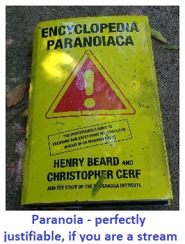
Above Platten Drive, the tributary is confined to a fenced off concrete channel on the Oak Creek community property, and is mostly mowed to the banks. Accumulated sediment has caused a little marshland to form in the channel at Platten Drive. Above Blake Lane there is a short stretch of the tributary that is not confined and has decent buffer as it flows through a private lot and the Edgemoor community property. Further upstream, the tributary is again confined to a concrete channel which is mostly mown to the banks. An eastern branch of the Draper Drive tributary feeds in through an adjacent stormwater pond here after traveling three blocks through storm drain pipes. An odd find in this channel was a discarded box of books, prominent among which was the "Encyclopedia Paranoica". But is it truly paranoia if you are a stream and are variously forced into concrete channels and pipes, used as a dumping ground, deprived of trees lining your banks, force-fed by storm drains, plagued with invasive species, eroded and choked with sediment? Could a stream be forgiven for thinking "they" really are out to get you? The last upstream trace of open water is a steady trickle running in the concrete ditches of the stormwater pond at Fox Spring Court on the Hunter Crossing community property. The eastern branch can be found above ground by looking north of Leamore Lane on the property of the Edgemoore, Oakton Plantation, and Old Courthouse Woods communities. The lower portion is mowed to the banks and lined with recent-looking stones. Farther upstream, the streambed is more natural and enjoys a narrow thread of wooded buffer, although dominated by invasive alien species. The last upstream water is found in a pair of stormwater ponds. No fish are found in the eastern branch. See all the July 2018 Draper Drive tributary photos at Shutterfly.com Ranger Road tributary July 2, 2018: Walked along the Ranger Road tributary of Accotink Creek
The Ranger Road tributary is a much-disturbed little stream, having no name of its own, just referred to by the name of a road it crosses, as found on the Fairfax City streams map.
The tributary meets Accotink Creek in Fairfax City, in Ranger Road Park, immediately south of Ranger Road. Upstream from Ranger Road, the tributary is narrowly confined between townhouses with only a slender strip of buffer on either side. The channel is marked with a series of stone vanes from stream restoration projects intended to reduce erosion. Just upstream from the townhouses, the tributary flows through Villa d'Este Park in Fairfax County. The stream restoration stonework continues a short ways upstream, but employing a markedly larger scale of stone than used in Fairfax City. Buffer is broad in Villa d'Este Park upstream from the restoration. Northwood Road, at the northern border of Villa d'Este Park, is a new road. The woods were cleared here for roadbuilding, leaving the stream open to the sky. The stone reinforcement at the upstream side of the road is failing, exposing geotextile leaving banks subject to erosion. Just above Northwood Road, a 300-yard stretch of the tributary is confined to a storm drain. No fish were observed upstream from the park. Above the storm drain section, upstream from Barnsbury Court, the tributary is free-flowing through the Mosbys Manor community property, with mostly fair buffer, but also some mowing to the bank. Above I-66, the Ranger Road tributary flows briefly through a modest wooded triangle of land of uncertain ownership (likely VDOT). The last upstream open water is here at Bushman Drive. We may expect extensive disturbance to the tributary and its woods here and on the south side of I-66 as the I-66 Outside the Beltway project proceeds. See all the July 2018 Ranger Road tributary photos at Shutterfly.com Mosby Woods Tributary of Accotink Creek: June 15 & 18, and July 29, 2018: Walked upstream along the Mosby Woods tributary of Accotink Creek in the Northwest Watershed area.
The Mosby Woods tributary joins the North Fork of Accotink Creek in the Willow Woods Open Space in Fairfax City. The main branches of the Mosby Woods tributary originate north of I-66 and flow through the heart of the cloverleaf at Chain Bridge Road. At its far upstream end, three tiny branches unite to form the main Mosby Woods tributary.
"Mosby Woods" is not an official name for this tributary, but rather a working title of convenience found on the Fairfax City streams map. The Mosby Woods tributary enjoys wide forested buffers along most of its lower length, in Willow Woods Open Space and Shiloh Street Park in Fairfax City, on the property between the Fairfax Village Apartments and Oakton Park Apartments, inside the I-66/Chain Bridge Road cloverleaf, and north of I-66, where the Mosby Woods tributary is an ephemeral trickle in large wooded private backyards. There are some places where the buffer is narrower on one side or the other, particularly where a few property owners have mowed too near the banks. The buffer and the cooling shade provided by trees may contribute to the abundance of small fish in the Mosby Woods tributary. Swirling schools are visible nearly every step of the way, even as far upstream as the portion of the cloverleaf north of I-66. This abundance is despite the several culverts the fish need to cross. Crayfish are not so easily spotted, but do seem more abundant than in most other parts of the Accotink Creek watershed. A snapping turtle showed up during this walk. The amount of trash is moderate along most of the North Fork, but is notably worse in the area just downstream from Chain Bridge Road. Unfortunately, some of the trash at this point is larger items which have clearly been dumped directly into the creek. Invasive alien plant species are present all along the North Fork, including Porcelainberry, Oriental bittersweet, Japanese stilt grass, Bush honeysuckle, Multiflora rose, and more. Infestations tend to be lesser in the shadier areas. The cloverleaf is a wilderness of invasive vines, obscuring the native trees beneath them. Just as streams flow downhill, so do sewer pipes. A cleared strip along the path of the sewer line runs next to the Mosby Woods tributary for most of its length in Fairfax City. The cleared strip is often the path of least resistance for walking, as there is no formal trail development along the creek and informal trails are largely missing as well. This appears to indicate the Mosby Woods tributary is little-visited by its neighbors. Public access is limited to a few points, notably at a formal (but unmarked) access point at Shiloh Drive, and an informal trail at the western terminus of Ranger Road. Stream stabilization projects cover the entire length of the Mosby Woods tributary within Fairfax City. U-shaped rock vanes one after another turn much of the stream into a series of stepping pools. These vanes may have been designed with fish passage in mind, as they are low and provide gaps that facilitate swimming through. As one walks upstream from the Fairfax City line, the restoration projects abruptly cease. A tributary joins at the Oakton Park Apartments off Willow Crescent Drive. This tributary spends much of its course flowing in the darkness of storm drains, but is above ground where it flows through the wooded interior of the I-66/Chain Bridge Road cloverleaf. There is much slack water within the cloverleaf, seemingly backed up above the culverts. This tributary has its origins at the AT&T campus on Chain Bridge Road north of I-66. There were only a couple possible sightings of fish on this tributary upstream of Willow Crescent Drive. There is a surprising abundance of native wild grape along the banks within the cloverleaf, amid the tangles of invasive alien plants. Big changes are coming to the Mosby Woods tributary. The I-66 Outside the Beltway widening project is getting underway, and is likely to spell doom for all the vegetation and fish in the cloverleaf. Much of the forested area will be permanantly lost to asphalt, despite replanting efforts in whatever small margins remain. We may also expect much sediment to be dumped into the Mosby Woods tributary during construction, just as Accotink Creek has endured during other big projects such as the 495 Express Lanes.
See all the June 2018 Photos at Shutterfly.com
Northwestern Main Stem area:
21 April, 2016: Walked upstream from the Pickett Road bridge, following the main stem of Accotink Creek through Fairfax City to its last upstream open water, a culvert under Hallman Street, near the intersection of Rt. 50 and Rt. 236.
Accotink Creek flows through narrow corridors in Fairfax City, with roads, houses, and buildings seldom out of sight, depriving the creek of adequate vegetated buffers. Many sections are quite straight, evidence of past channelization for the convenience of humans. Clearly, many areas were cleared right to the banks in the past. There have been numerous projects here over recent years to attempt to stabilize the creek and improve its biological health. The signs are everywhere - large blocks of granite placed to hold banks or direct flow, and an unnaturally common prevalence of planted native streamside species River birch and Black willow. Alien invasive plants are especially common in the northwestern watershed due to past clearing. Invasive species are early colonizers of disturbed areas. As is common in most streams in our area, excess erosion caused by stormwater runoff from paved services is everywhere, as testified by the steeply incised banks. Most of the property along this portion of Accotink Creek is owned by the City of Fairfax, mostly as parks. Some portions are privately owned, variously as backyards of homes, civic association property, or parts of commercial parcels. One of those parcels is the Army-Navy Country Club, where the Daniels Run tributary enters from the south. The stream bed and banks are littered with stray golf balls there. An especially forlorn section between Main Street and Meadow Bridge Lane is also in private parcels. Here structures intrude on the stream banks, trash is unusually abundant, and the neighbors clearly hold the creek in lowest regard. Obstacles to fish movement are abundant, principally in the form of old utility pipes crossing the streambed. These are presumably sewer pipes or water mains that are likely no longer in service. Originally these would have been buried, but have been left exposed by the excess erosion plaguing our urban streams. Still, small fish are relatively common along the main stem here, and occasional larger ones can be spotted as well, so they seem to manage to adapt. The Friends of Accotink Creek have three Adopt-A-Stream cleanup sites here, where Accotink Creek crosses Old Lee Hwy, Fairfax Blvd, and Chain Bridge Road. April 2016 Photos at Shutterfly.com Dale Lestina Park area: 12 & 13 April 2012: Walked upstream from the mouth of unnamed tributary running through Dale Lestina Park in Fairfax City north to its uppermost outlet. This small tributary pours out of a culvert under Ranger Road directly into Accotink Creek in Ranger Road Park next to the Cambridge Station community in Fairfax City. Developments along this tributary were built in in the decades before Resource Protection Area (RPA) requirements were in place, mandating set-backs and vegetated buffers along streams. Homes are thus too close to the stream in many spots, depriving it of the natural wooded buffer that offers so many benefits: shade, slowed runoff, increased infiltration into groundwater, absorption of pollutants, sources of organic nourishment for aquatic life. Upstream from the Cambridge Station community, the stream flows across the southwest corner of Villa d’Este Park in Fairfax County. Above that, as far upstream as Plantation Parkway, the stream flows through Fairfax City’s Dale Lestina Park. Restoration projects are visible along all of the Fairfax City portion of the stream. Techniques used include bank reshaping and reinforcement and the use of numerous stone weirs to direct the current away from the banks and also push floodwaters up onto the flood plain to disperse energy that would otherwise scour away the stream banks. Few fish were spotted below Plantation Parkway, but fish are common between Plantation Parkway and I-66. No fish were spotted upstream from Bushman Drive. Upstream from I-66 the course of the stream is in Fairfax County. The stream flows underground in storm drains between Bushman Drive and Jermantown Road. There are depressing amounts of invasive alien plant species along most of the stream. There is little trash, however, except in the stormwater pond just above I-66. A stormwater pond above Blake Lane appears to be the last upstream source for this tributary.
Nearby, an even smaller unnamed tributary was the object of a recent Fairfax County stormwater pond project, part of the county’s Accotink Creek Watershed Plan , a 25-year to-do list of enhancements to the water quality of Accotink Creek.
April 2012 Photos at shutterfly.com
Do you live near or sometimes visit the Northwestern Watershed of Accotink Creek? Let others know what you have seen! Share your own observations/comments on this or other sections of the Accotink Creek watershed. |